It’s time to rethink how we prioritize public investments to create a more resilient future for all Washingtonians.

Washington shellfish growers receive funding from the Supporting Oyster Aquaculture and Restoration (SOAR) program’s Shellfish Growers Resiliency Fund, investments in new and more sustainable solutions to common aquaculture practices.
Earth Day was born out of a movement to improve the lives of people and nature, inspiring sweeping legislative action and investments. Today, federal infrastructure funding and WA Climate Commitment Act are a continuation of this movement, investments making a tangible impact locally. As an example, Washington’s historic funding of the Floodplains by Design program is contributing to nature-based floodplain management across the state to reduce flood risk, protect communities and protect salmon habitat. These state and federal dollars are just the start of local climate action that will improve the daily lives and the future of all Washingtonians.
Meet DeAnne Hamilton: Learn how the general manager of Tacoma’s KBTC Public Television and TNC in Washington trustee, uses the power of storytelling to engage people in conservation and create a better future for the next generation.
Nestled in the cliffs in Moses Coulee is an import desert water sources that every springs attracts thousands of Pacific Tree frogs. I came to Whisper Lake for a night concert. It was anything but quiet. The chorus of frogs was soothing, calming—the quintessential sound of spring.
The Cle Elum Wildlife Project is improving our understanding of how wildlife use and move through protected forest landscapes, providing us with an opportunity to test how forest management practices impact wildlife and building an evidence base for permanent protection.
Written & Photographed by Brian Mize, Field Forester
Recently, I was traveling through our Central Cascades lands, noticed a strong odor and saw a small amount of smoke approximately 200’ off the road. I am very familiar with this particular location because it has been a popular spot with the local firewood poachers.
I hiked off the road and found a campfire that had escaped the ring and burned a small area. At that time, the fire was just smoldering and there was nobody around.
Acting quickly, I called the Central Washington Interagency Communication Center in Wenatchee, and they sent out the dispatch to any local fire engines. A Forest Service engine was the first to respond and arrived shortly after. They ran a quick hose line to the fire and extinguished all the heat and put a hand line around the burned area. Afterwards, a Dept. of Natural Resources engine arrived along with a DNR law enforcement officer.
This was clearly a human caused fire, but we did not find any evidence that could pinpoint any specific individuals. There was evidence of recent firewood theft in the immediate vicinity.
Overall, this ended up being a small incident; however, if I had not spotted this fire when I did, it could have developed into something greater in scope. This area is very brushy, steep, and the high temps that day were above 90 degrees. With a little wind, this fire had high potential for spread.
We love that we can provide as much access to the outdoors as possible to our local communities with our lands. It was a good reminder that although fire season has been off to a slow start this summer, we still have a long way to go.
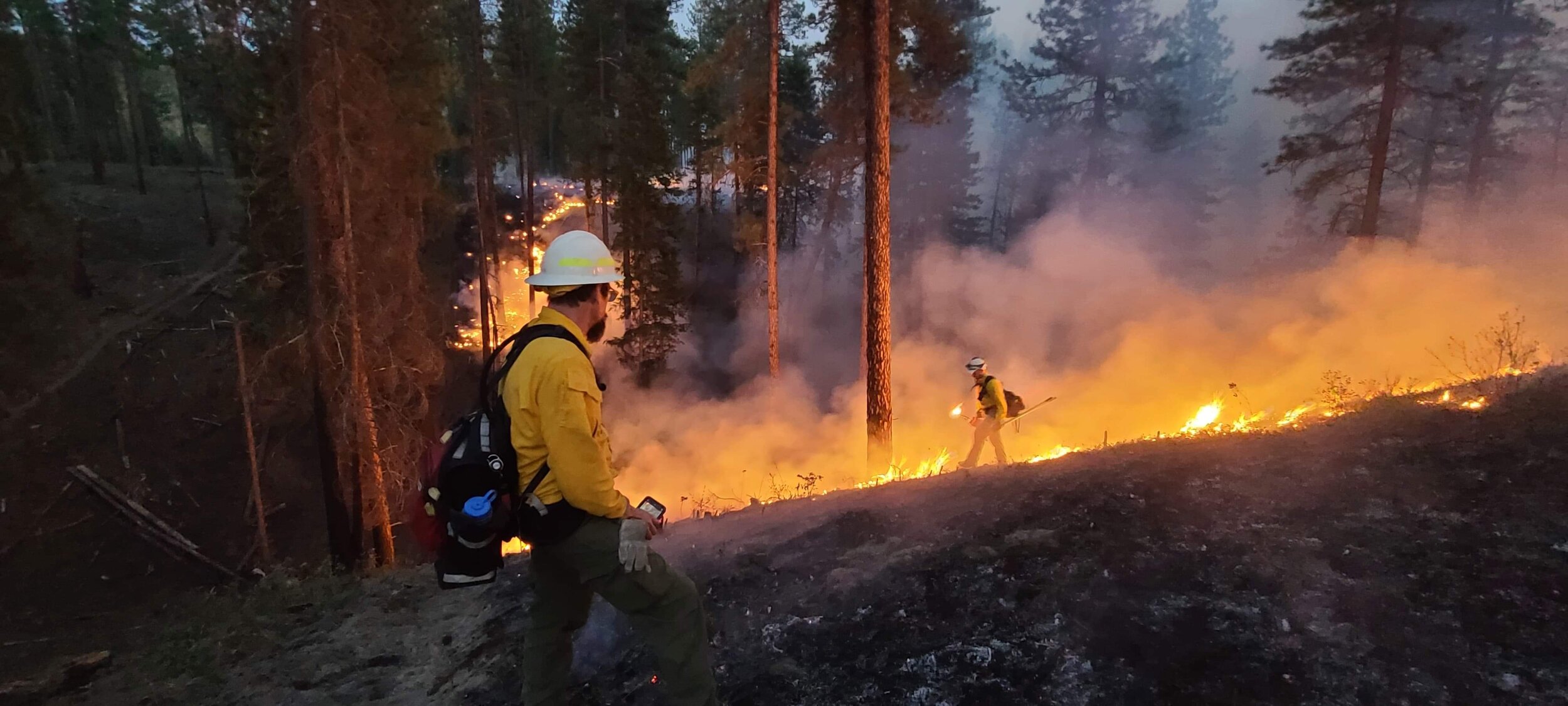
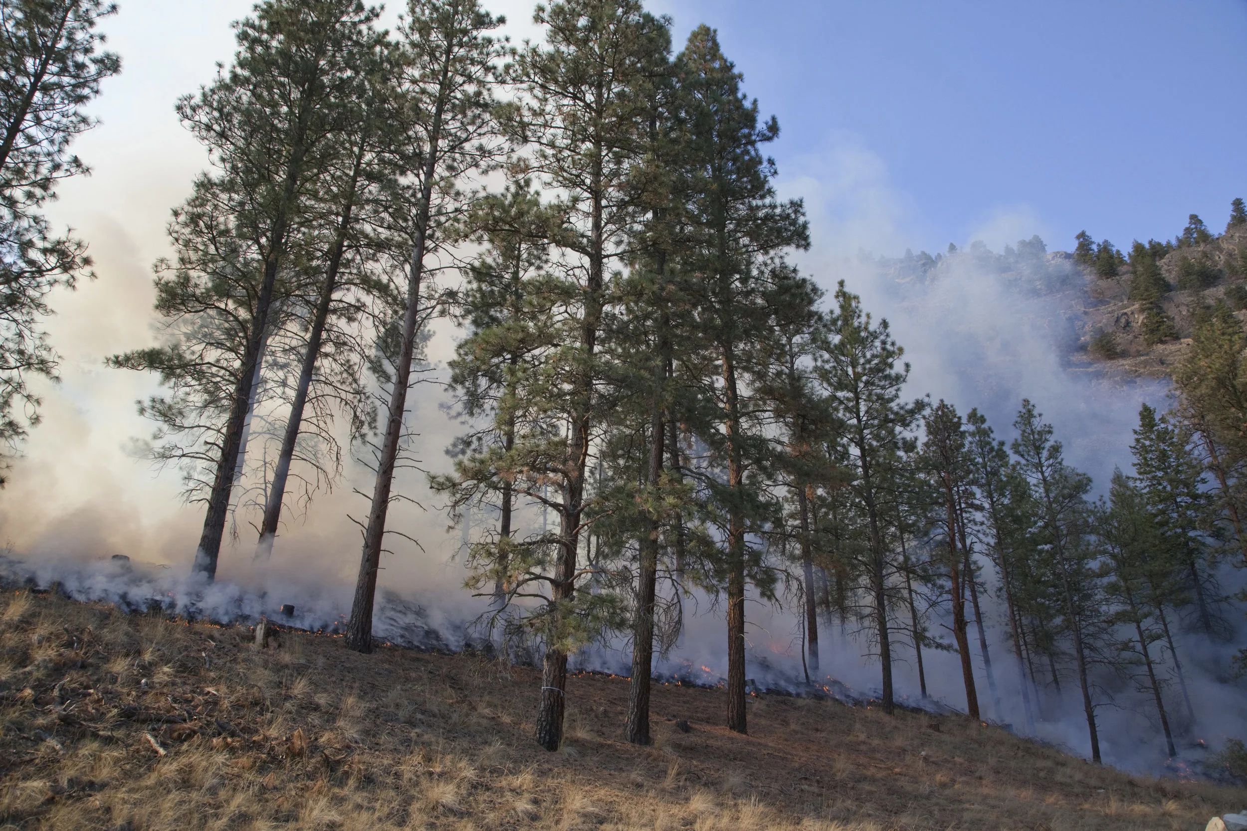
The Northeast Washington TREX brings participants into a collaborative environment designed to increase shared stewardship and learning across agencies.
Unlike the large wildfires burning across the West this summer, these are intentionally set fires designed to protect communities and restore forests.
The federal government will now be able to use disaster relief dollars to pay for fighting catastrophic wildfires, which will fund wildfire suppression like other natural disasters.
What can trees tell us about wildfire and healthy forests? Check out our web story to find out!
A controlled burn on private forest land that is designed to protect the town of Roslyn and improve forest health is being planned for the week of Oct. 2 as part of a fire learning exchange in North Central Washington.
Controlled burning, is a time-tested and effective tool that maximizes the benefits that low-intensity fire can provide within a variety of landscapes.
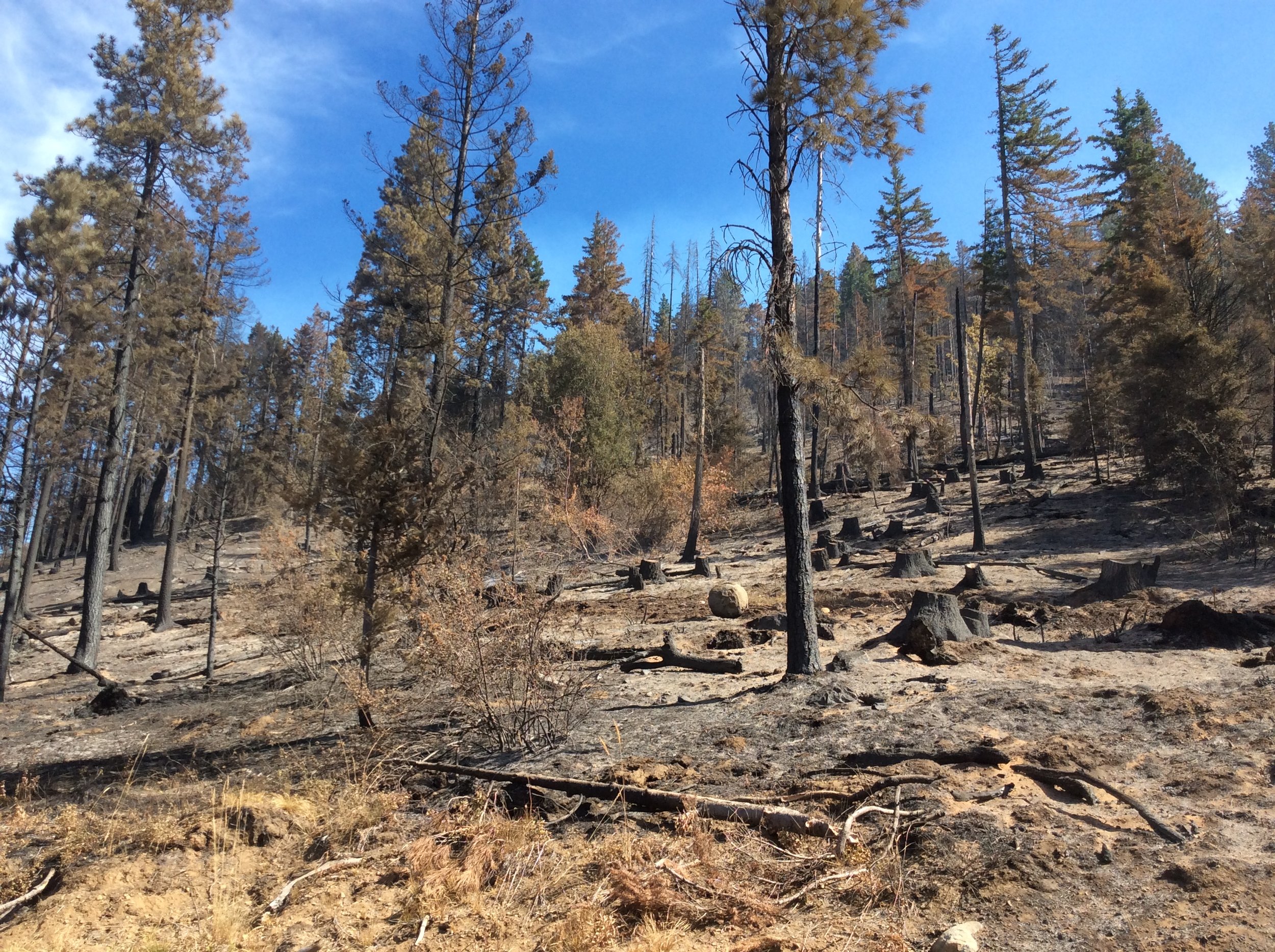
Devastating fires continue to burn across our state. But we’ve now had our first look at roughly 1,800 acres of Nature Conservancy land that burned in the Jolly Mountain Fire
With fires raging across the state, our first concern right now is the safety of people, including our staff, community members and firefighters.
Learn how we are setting the stage for healthier forests and safer, more economically vibrant communities.
Graphics by Erica Simek Sloniker, Conservation Information Manager
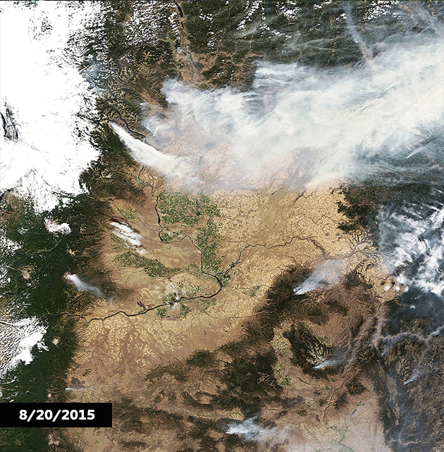
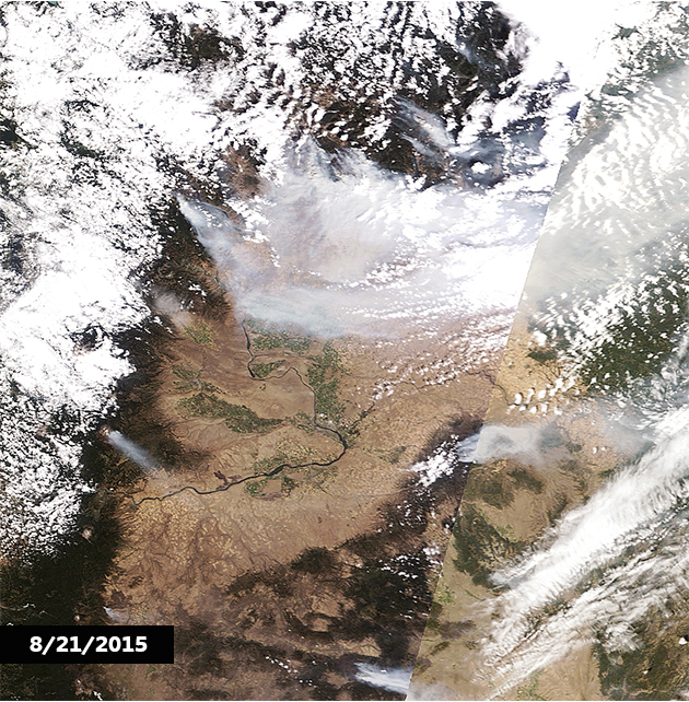
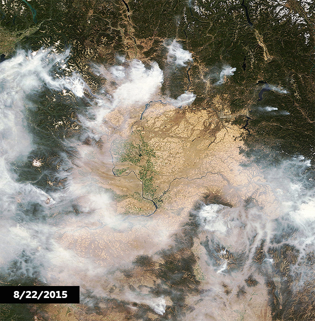
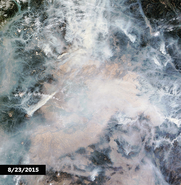
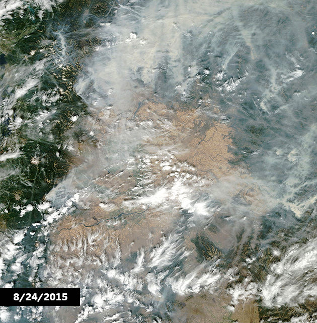
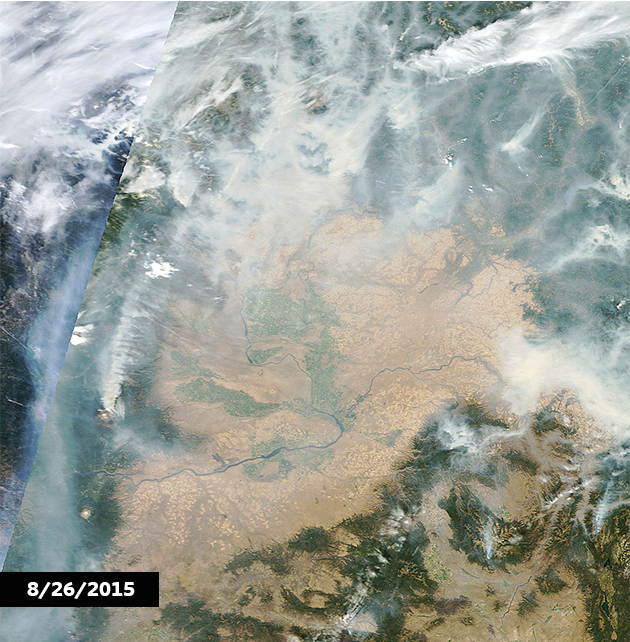
These Washington wildfires are now the largest in state’s history. Check out these NASA - National Aeronautics and Space Administration maps that capture the past week in smoke from space in the slideshow above, then explore Washington State University’s smoke projection mapping tool!