Support nature’s resilience and help keep climate-friendly transit options available across Washington: Join us in voting NO on I-976.

Washington shellfish growers receive funding from the Supporting Oyster Aquaculture and Restoration (SOAR) program’s Shellfish Growers Resiliency Fund, investments in new and more sustainable solutions to common aquaculture practices.
Earth Day was born out of a movement to improve the lives of people and nature, inspiring sweeping legislative action and investments. Today, federal infrastructure funding and WA Climate Commitment Act are a continuation of this movement, investments making a tangible impact locally. As an example, Washington’s historic funding of the Floodplains by Design program is contributing to nature-based floodplain management across the state to reduce flood risk, protect communities and protect salmon habitat. These state and federal dollars are just the start of local climate action that will improve the daily lives and the future of all Washingtonians.
Meet DeAnne Hamilton: Learn how the general manager of Tacoma’s KBTC Public Television and TNC in Washington trustee, uses the power of storytelling to engage people in conservation and create a better future for the next generation.
Nestled in the cliffs in Moses Coulee is an import desert water sources that every springs attracts thousands of Pacific Tree frogs. I came to Whisper Lake for a night concert. It was anything but quiet. The chorus of frogs was soothing, calming—the quintessential sound of spring.
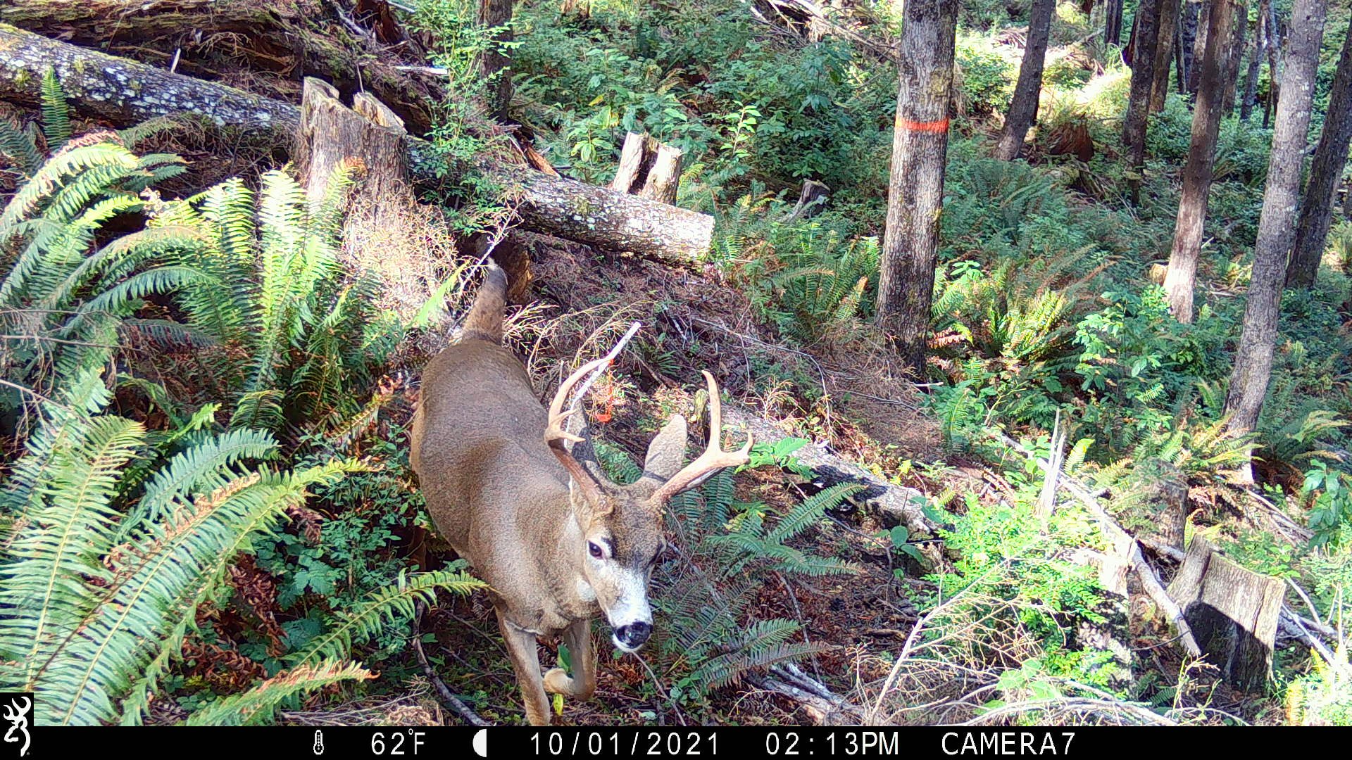
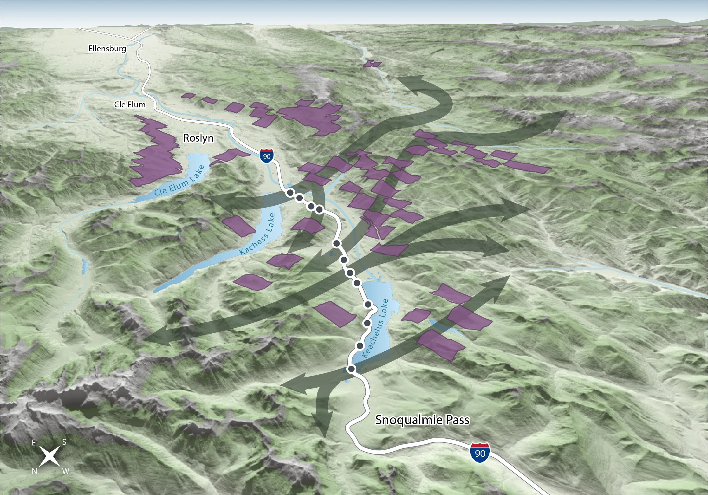
The Cle Elum Wildlife Project is improving our understanding of how wildlife use and move through protected forest landscapes, providing us with an opportunity to test how forest management practices impact wildlife and building an evidence base for permanent protection.

Written by Zoe van Duivenbode, TNC Intern
Photo by Walt Kochan; Joel Rogers
June is officially Orca Month! These marine mammals are so magnificent they deserve a whole month filled with orca appreciation and fun educational events! Recently, orcas have been coined as the first non-human species whose evolution has been influenced by each group’s unique cultural differences, such as hunting methods and vocalization. While certain groups of orcas snack on sting-rays and squid, other groups, like the local Southern Resident Killer Whales exclusively feed on chinook salmon and other fish!
For the entire month of June, dedicated orca lovers and various organizations unite to help spread the word about the rapidly declining population of the Southern Resident Killer Whales. Between the years of 1995 to 2001, the Southern Resident Killer Whale population decreased by 20% and as of December 2015, our resident pods reached a total of 84. One of the most detrimental threats to our underwater neighbors involves the reduction of chinook salmon populations and their habitat. The Orca-Salmon Alliance, The Center for Whale Research, and the Orca Network are just a few organizations that are hosting educational events highlighting the important relationship between the Southern Resident Killer Whales, salmon and a healthy Puget Sound ecosystem over drinks, picnics, storytelling and music. Visit The Orca Month page to find all the fun events happening near you!
The Nature Conservancy is hard at work protecting both habitat and food supply for the Southern Resident Killer Whales. TNC’s efforts to decrease the amount of toxic stormwater runoff that drains into the Puget Sound will help create a cleaner home for all marine life, including orcas! Check out how TNC’s plans to solve stormwater issues in our cities to help increase our region’s salmon population, which in turn, increases our Southern Resident Killer Whale population!
Nestled in the cliffs in Moses Coulee is an import desert water sources that every springs attracts thousands of Pacific Tree frogs. I came to Whisper Lake for a night concert. It was anything but quiet. The chorus of frogs was soothing, calming—the quintessential sound of spring.
The Cle Elum Wildlife Project is improving our understanding of how wildlife use and move through protected forest landscapes, providing us with an opportunity to test how forest management practices impact wildlife and building an evidence base for permanent protection.
A game camera on the Moses Coulee Preserve has captured just how much a gate that sits at the intersection of quality shrub-steppe and agricultural fields is used by visitors and residents, even when closed.
Preliminary data from the Ellsworth Creek Wildlife Project tests assumptions of forest thinning restoration practices.
What do bats sound like? Every August for the past three years, the Conservancy has participated in the North American Bat Monitoring project. Let us walk you through how and why we monitor bats.
Imagine waking up one morning and finding your neighborhood had been split in two, separated by a moat that is impossible for you to cross.
Some wildlife are more camera-shy than others. Check out some of our preserves' wildlife that have been caught on camera traps!
Last week, Phil Green finally had decent weather to get to Goose and Deadman islands to do what is now yearly monitoring.

Written and Photographed by Mitch Pittman, Northwest Photojournalist
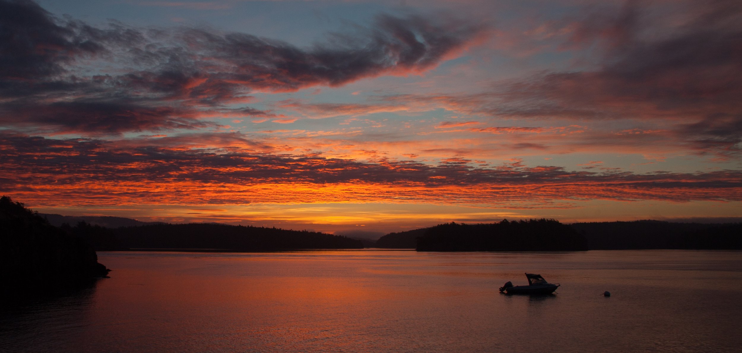
More vivid than the colors of the sunset are the memories that surround it. Rain was forecast for the Western side of the state, so my friend Erin (pictured) and I headed towards Quincy, Washington and a little cluster of lakes we’d heard about on social media.
Ancient Lakes is unlike any other place I’ve been to in Washington - towering cliffs conceal the farmlands above and take you back in time, coyotes scamper through sage brush, waterfalls appear out of nowhere to spill down the walls and fill the air with a soft roar, and at the back of this broad valley are the lakes.
After exploring an upper valley, we started to head back to the car just before sunset and found ourselves on top of the main waterfall right as the real show began. My mind, let alone my shutter finger, could hardly keep up with the brilliant, glowing air around me. Within minutes, this shot appeared out of the dull desert grey. After I snapped this, Erin shouted for me to turn around - a rainbow against a tangerine sky! From there the pinks, purples, blues, and yellows just kept coming.
I realized a few minutes in that even trying to capture the full beauty of what was happening around me was pointless, so I eventually set down my camera and simply enjoyed the rest of the show in silent awe with my dear friend.
Those are my favorite images of the day.
Mitch Pittman lives in Seattle and works as a reporter and photojournalist for KOMO 4 News, but many of his favorite stories to tell are during his time off exploring the beautiful areas of this state. You can follow his trips on Instagram (@mitchpittman) or on his website.


Well Worth it – Capturing the Color of the Mountains
Hiking the Enchantments, Alpine Lakes Wilderness
Story and Photographs by Andy Porter
The Enchantments are a part of the Alpine Lakes Wilderness, (which is itself a part of the Wenatchee National Forest) located near the town of Leavenworth, along Highway 2, in Washington State.
The Enchantments area is actually very small, making upmaybe 10 square miles. Packed in to this wondrous world there are scads of small lakes and tarns of fantastic hues of blue and green surrounded by stark jagged peaks. Autumn brings fantastic colors. Because of the high elevation of the Enchantments Basin (between 6,000 and 8,000 feet) there are dense stands of larch. These trees have needles, and come fall they turn a bright orange color, and look like they are aglow from inside.
I spent some time reading about the trail and lakes, the approach and parking and all that. There are two routes in to -or rather up to- the Enchantments Basin. One is very long (12 miles) with a lot (more than 6,000 feet) of elevation gain. The other route is a little shorter, and has a little less elevation gain, but it includes a hike up Aasgard Pass (more than 2,000 feet up in less than one mile).
I recruited two of my friends to help me use the 5-day permit I’d won. I gave them fair (sort of) warning about the hike.
The first day’s short hike took us up to Colchuck Lake. We arrived late in the day and from the lake could see the gash of Aasgard Pass soaring above the lakes far edge. Late morning finds us clambering over the boulder fields along the lake at the base of the trail up. The morning light flares behind the larch atop the pass.
The hike up to the top of the pass was… arduous.
Once you manage to crest the pass you arrive in a wonderland of rock and ice. Dragontail Peak’s serrated edge rips the sky asunder above Isolation Lake. Ice fields dot the lake’s edge. A cool wind and a long drink from the icy stream revive me. There are several inviting tent spots here and we quickly set up our portable North Face fortress and prepare food. There are a smattering of larches up here in the alpine zone, but mostly it’s rocks and water.
The light starts to fade and the colors glow along the lakes shore, the blues, greens and pinkish reds don’t look real at all. Late at night I manage to drag myself out of the tent and capture a few shots of the stars and the tent in this moon-ish looking landscape.
The next day as we start hiking I tell my two friends that this will probably be one of the best days hiking ever. We set out excited to see what the day has to offer.
Skirting a low ridge we drop into a new basin filled with countless ponds. We cross a small snow field as we make our way gently down the trail. Our goal for the day is to establish a new camp on a ledge above Crystal Lake and then hike down to Perfection Lake. From there the plan I have is to make our way up to tiny Gnome Tarn for some wonderful views of Prussik Peak reflected.
Each turn of the trail elicits a new sense of wonder. The larches thicken as we descend.
Overlooking Crystal Lake our new camp gloriously commands a wonderful view. Below us the ridges are crusted in orange larch, offset by the blue skies and green lakes. Once camp is set up we (now without heavy packs!) set out for Perfection.
This basin is on fire with orange. As a true color junky I am juiced to my eyeballs with sensory overload. I feel like I’ve been teleported to a new world, like Avatar, or a scene from Middle Earth. Finding the trail junction amid an orange forest, we branch off and start the easy climb up to Prussik Pass, in search of Gnome Tarn.
A little searching and gawking later were there. The place is as promised, nestled at the base of Prussik Peak, exquisitely framed by larch and water. I enter a photographic trance state.
It’s a perfect day, sunny and warm, a cool breeze refreshes us as we bask in the glory of nature. Lingering for lunch we now set off again. Ambling my way back up to camp I encounter a few hikers who report mountain goats ahead. I arrive back at camp and there is a Mom and her young kid, looking for grass and munching away. A new photo frenzy starts I circumnavigate the goats several times as they make their way about.
Finally tiring of goats and picture taking, I go fire up the stove and make some coffee. My friends return and we marvel at all around us. Dinner is served and eaten just in time for the sunset.
The small ponds make wonderful reflections of the sky. Early the next morning the skies are dark and we head back to to the Pass and start the slow descent to Colchuck Lake. Taking a break on a huge slab precariously perched above a stand of larch I capture one last image of larch and lake.
Andy is a nature photographer lured to Washington State by the glorious vistas. He lives along the North Cascades Highway, where he teaches photography and leads photo tours. You can see more of his work at: www.AndyPorterImages.com

Washington Coast Gets Sustainable Business Boost
By Eric Delvin, Community Conservation Coordinator
Photograph by Bridget Besaw
What does a business competition have to do with conservation? The Nature Conservancy is committed to a future in which nature and people thrive together. On the Washington Coast, generations have drawn their livelihoods from a wealth of natural resources—abundant salmon and shellfish and trees that grow faster than anywhere else in the world.
As those resources become more stressed, coastal communities are seeking new ways to sustain themselves economically. Strong local communities and empowered local leadership are crucial for longterm stewardship of these natural resources.
Washington Coast Works is a competition that will give budding tribal and rural entrepreneurs a boost. It’s designed to diversify the local economy through the development of new small businesses, build business leadership in local communities, grow a constituency that supports conservation and sustainable natural resource use, and ultimately contribute to a new vision of sustainable community and economic development on the Washington Coast.
The competition is being presented by The Nature Conservancy in partnership with the Center for Inclusive Entrepreneurship at Pinchot University (formerly Bainbridge Graduate Institute) and the Taala Fund. USDA has granted $74,600 through its Rural Business Opportunity Grants to help launch the competition.
The goal is to launch sustainable local businesses that will increase local employment and have positive social, ecological, and economic impacts on their rural communities.
“We have a wealth of natural resources, and the talent to develop new, sustainable ways to use them,” said Rod Fleck, Forks city attorney/planner. “This is a great opportunity for our community’s entrepreneurs to develop new businesses or improve existing ones.”


By Bob Carey, Strategic Partnerships Director
Photography by Julie Morse and Tom Bugert
How do you create a regional vision for Puget Sound’s rivers and floodplains? By bringing together diverse stakeholders for a day of strategizing on how to develop the funding, science, partnerships and permits needed to manage our river systems more sustainably and effectively.
The third Floodplains by Design partnership workshop, organized by The Nature Conservancy and held in February 2015, was attended by more than 160 people—all focused on improving floodplain management across the region. In the crowd: tribes, agriculture, state and federal agencies, municipalities, counties, universities, business and environmental organizations. The diversity of interested parties and partners is part of what makes this program so unique and successful.
The meeting highlighted the substantive, on-the-ground results that have been accomplished over the last year and the work that lies ahead to generate the funding and plans needed to realize Floodplains by Design goals. Breakout sessions helped participants think about new ways to implement their work. Among the topics:
The day was filled with information sharing and useful connections that will help everyone in their work. There’s a power in feeling like part of a bigger effort. As one participant said, “These events always rekindle my enthusiasm!”
The popularity of these workshops shows growing interest in this innovative effort to make our floodplains more productive and resilient for people and nature. Generous support from these partners makes these events possible: U.S. Environmental Protection Agency, Washington Department of Ecology, NOAA Fisheries, Boeing Company, Puget Sound Partnership, the Russell Family Foundation and the National Fish and Wildlife Foundation.
Participants came away inspired, and so did the Nature Conservancy and FbD partner staff. Seeing the passion for a program that is making a difference fills us with new ideas and energy as we work to implement floodplains projects that protect our communities and restore our rivers.


Illabot Creek
By Bob Carey, Strategic Partnerships Director, The Nature Conservancy in Washington
Most of us who have spent time in the Pacific Northwest have heard our elders and old-timers spin tails of being able to walk across rivers on the back of salmon. Very few of us actually get to experience salmon in the kind of concentrations that spurred such tails. Yet that’s exactly what I saw one day on Illabot Creek!
I was on a research expedition on the Skagit River. My colleagues and I pulled our canoe up on a gravel bar at the mouth of Illabot Creek. The lower reach of Illabot, where it empties itself into the Skagit River, flowed black. Or so we thought.
What first appeared to be a river darkened by a bed of leaf litter, turned out to be a river chock-full of salmon! From bank to bank for a 100 yards upstream Illabot Creek was packed with thousands and thousands of pink salmon — awaiting their upstream journey to spawn and hatch the next generation that would follow the same incredible journey to the north pacific and back, feeding killer whales, seals and humans along the way.
The incredible concentrations of fish and wildlife in Illabot Creek have made it a focal point for conservation efforts by The Nature Conservancy and other private, public and tribal partners over the years. It supports some of the largest salmon and trout populations in the Skagit River system – itself one of the biggest producers of salmon in the coterminous United States.
Through the years, in cooperation with our partners at Seattle City Light, WA Department of Fish and Wildlife, Skagit Land Trust, US Forest Service, Skagit River System Cooperative and others, much of the land in the Illabot Creek watershed has been placed in long-term conservation ownership. Protecting the land does not guarantee the water will be protected, and over the years more than one proposal has surfaced to build a hydroelectric dam on the river – potentially blocking fish passage, inundating rich habitat, and altering stream flows the sustain downstream habitat.
So a few years back, in collaboration with a large suite of local and state partners, we developed a proposal to build on our successful land conservation efforts and provide long-lasting protection of the waterway itself.
As of today, and thanks to the leadership of this region’s Congressional delegation, Illabot creek will continue to run free.
It will continue to host the salmon runs and wintering eagle populations that have helped bring the Skagit its fame. Congress has designated Illabot Creek as a national Wild and Scenic River. The incredible natural phenomenon I saw there years ago will be present for future generations.
Illabot Creek will continue to run free.